代码如下:
代码如下:
Highcharts.mapChart(this.containerID, {
chart: {
renderTo:this.containerID,
backgroundColor:’’,
type: ‘map’,
borderWidth: 0,
spacing: [0,0,0,0],
map:‘geojson’,
},
credits: {
enabled: false
},
navigation: {
buttonOptions: {
enabled: false
}
},
title: {
text: ‘’,
},
legend:chartoption.legend,
plotOptions:{
map: {
allAreas: false,
},
series:{
mapData: json_city,
joinBy: ‘id’,
keys: [‘id’, ‘id’],
dataLabels:{
enabled: true,
formatter:function(){
return this.point.name;
}
}
}
},
tooltip:chartoption.tooltip,
series: [
{
type:‘map’,
name:‘Basemap’,
data:[
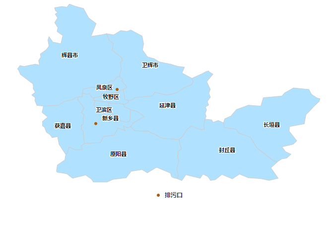
{id:“410711”,name:‘牧野区’,color:’#b0e2ff’},
{id:“410703”,name:‘卫滨区’,color:’#b0e2ff’},
{id:“410728”,name:‘长垣县’,color:’#b0e2ff’},
{id:“410727”,name:‘封丘县’,color:’#b0e2ff’},
{id:“410782”,name:‘辉县市’,color:’#b0e2ff’},
{id:“410724”,name:‘获嘉县’,color:’#b0e2ff’},
{id:“410781”,name:‘卫辉市’,color:’#b0e2ff’},
{id:“410726”,name:‘延津县’,color:’#b0e2ff’},
{id:“410725”,name:‘原阳县’,color:’#b0e2ff’},
{id:“410702”,name:‘红旗区’,color:’#b0e2ff’},
{id:“410704”,name:‘凤泉区’,color:’#b0e2ff’},
{id:“410721”,name:‘新乡县’,color:’#b0e2ff’},
],
showInLegend: false,
enableMouseTracking: false,
},
{
type:‘mappoint’,
name:‘排污口’,
data:[{
name:‘新乡县’,
lat:35.2,//35.3595,
lon:113.8,//114.2029,
},{
name:‘凤泉区’,
lat:35.38399,
lon:113.91507,
}],
// joinBy: ‘name’,
// keys: [‘id’, ‘name’],
marker:{
fillColor:’#aa5e11’,
radius:‘3’,
},
}
]
});
}
json_city = {
“type”: “FeatureCollection”,
“name”: “json_city”,
“crs”: { “type”: “name”, “properties”: { “name”: “urn:ogc:def:crs:OGC:1.3:CRS84” } },
“features”: [{
“type”: “Feature”,
“properties”: {
“name”: “牧野区”,
“id”: “410711”
},
“geometry”: {
“type”: “MultiPolygon”,
“coordinates”: [
[
[
[113.977345, 35.3238430000001],
[113.969488554688, 35.3083132148438],
[113.947345, 35.303843],
[113.917615996094, 35.3111452460938],
[113.902345, 35.3077223945313],
[113.892345, 35.3099636054688],
[113.882066679688, 35.3076601386719],
[113.867345, 35.3138430000001],
[113.83170046875, 35.3181996894532],
[113.797345, 35.3238430000001],
[113.787345, 35.3238430000001],
[113.787345, 35.333843],
[113.790704375, 35.3404836250001],
[113.835474882813, 35.3474330878906],
[113.829163847656, 35.3603591132813],
[113.913985625, 35.367202375],
[113.947345, 35.383843],
[113.956553984375, 35.3296327949219],
[113.977345, 35.3238430000001]
]
]
]
}
}, {
“type”: “Feature”,
“properties”: {
“name”: “卫滨区”,
“id”: “410703”
},
“geometry”: {
“type”: “MultiPolygon”,
“coordinates”: [
[
[
[113.897345, 35.233843],
[113.853267851563, 35.2230165839844],
[113.840184355469, 35.2579824042969],
[113.801429472656, 35.2679274726563],
[113.788441191406, 35.3026418281251],
[113.797345, 35.3238430000001],
[113.83170046875, 35.3181996894532],
[113.867345, 35.3138430000001],
[113.87170046875, 35.2781996894532],
[113.88298953125, 35.2694863105469],
[113.897345, 35.233843]
]
]
]
}
}, {
“type”: “Feature”,
“properties”: {
“name”: “长垣县”,
“id”: “410728”
},
“geometry”: {
“type”: “MultiPolygon”,
“coordinates”: [
[
[
[114.976221953125, 35.2949684882813],
[114.947906523438, 35.2632802558594],
[114.932061796875, 35.2491237617188],
[114.922628203125, 35.1985622382813],
[114.8429309375, 35.1836867500001],
[114.841480742188, 35.1593166328125],
[114.882061796875, 35.1069460273438],
[114.862628203125, 35.0885622382813],
[114.802628203125, 35.0746022773438],
[114.822061796875, 35.0485622382813],
[114.851221953125, 35.0351784492188],
[114.827345, 35.0138430000001],
[114.80142703125, 35.0097585273438],
[114.777345, 34.993843],
[114.754019804688, 35.0005117011719],
[114.666534453125, 35.0704799628907],
[114.633023710938, 35.1256520820313],
[114.571793242188, 35.1482900214844],
[114.555152617188, 35.1690676093751],
[114.491793242188, 35.1782900214844],
[114.487345, 35.2038430000001],
[114.493897734375, 35.2256117988281],
[114.527213164063, 35.2404787421876],
[114.5573840625, 35.2754958320313],
[114.622105742188, 35.2992641425782],
[114.68834109375, 35.2939418769531],
[114.70197390625, 35.3392153144532],
[114.80271609375, 35.3484706855469],
[114.8173840625, 35.3654958320313],
[114.864815703125, 35.3919582343751],
[114.947345, 35.383843],
[114.96181765625, 35.3572084785157],
[114.99142703125, 35.3379274726563],
[115.007345, 35.333843],
[115.002628203125, 35.3185622382813],
[114.976221953125, 35.2949684882813]
]
]
]
}
}, {
“type”: “Feature”,
“properties”: {
“name”: “封丘县”,
“id”: “410727”
},
“geometry”: {
“type”: “MultiPolygon”,
“coordinates”: [
[
[
[114.423714628906, 35.2202114082031],
[114.431461210938, 35.2066249824219],
[114.459097929688, 35.2170412421876],
[114.487345, 35.2038430000001],
[114.491793242188, 35.1782900214844],
[114.555152617188, 35.1690676093751],
[114.571793242188, 35.1482900214844],
[114.633023710938, 35.1256520820313],
[114.666534453125, 35.0704799628907],
[114.754019804688, 35.0005117011719],
[114.777345, 34.993843],
[114.772628203125, 34.9885622382813],
[114.742760039063, 34.9618788886719],
[114.782061796875, 34.9056130195313],
[114.733502226563, 34.8939809394532],
[114.687345, 34.9038430000001],
[114.62142703125, 34.9079274726562],
[114.573912382813, 34.92788596875],
[114.534698515625, 34.9023537421875],
[114.4791028125, 34.9257057929688],
[114.44326296875, 34.8979274726563],
[114.417345, 34.893843],
[114.402762480469, 34.9149648261719],
[114.377069121094, 34.9279274726563],
[114.36154421875, 34.9054433417969],
[114.284595976563, 34.9243434882813],
[114.263001738281, 34.8930678535157],
[114.237345, 34.9038430000001],
[114.243529082031, 34.9185646796875],
[114.235618925781, 34.953843],
[114.245706816406, 34.998843],
[114.240103789063, 35.023843],
[114.243465605469, 35.038843],
[114.241073027344, 35.0495131660156],
[114.259945097656, 35.0625429511719],
[114.247345, 35.113843],
[114.259564238281, 35.1232741523438],
[114.29170046875, 35.1694863105469],
[114.314217558594, 35.1868666816407],
[114.364783964844, 35.16698753125],
[114.384407988281, 35.1698867011719],
[114.381600371094, 35.1888771796875],
[114.387345, 35.223843],
[114.423714628906, 35.2202114082031]
]
]
]
}
}, {
“type”: “Feature”,
“properties”: {
“name”: “辉县市”,
“id”: “410782”
},
“geometry”: {
“type”: “MultiPolygon”,
“coordinates”: [
[
[
[113.685875273438, 35.8323744941406],
[113.733079863281, 35.8195778632813],
[113.761610136719, 35.7681081367187],
[113.801307402344, 35.7385793281251],
[113.773570585938, 35.6695778632813],
[113.833079863281, 35.6781081367188],
[113.857345, 35.683843],
[113.87170046875, 35.6481996894531],
[113.893463164063, 35.6314028144532],
[113.88797, 35.5942360664063],
[113.940941191406, 35.5533498359376],
[113.943160429688, 35.5383315253907],
[113.931529570313, 35.5293544746094],
[113.936715117188, 35.4942763496094],
[113.927345, 35.453843],
[113.911429472656, 35.4497585273437],
[113.895697050781, 35.4269704414063],
[113.878992949219, 35.4307155585938],
[113.845697050781, 35.3824867988282],
[113.782345, 35.3966896796875],
[113.7329309375, 35.3856117988281],
[113.727345, 35.3638430000001],
[113.727345, 35.343843],
[113.707345, 35.343843],
[113.691429472656, 35.3397585273438],
[113.673260527344, 35.3279274726563],
[113.631429472656, 35.3197585273438],
[113.5983215625, 35.2981996894531],
[113.517345, 35.293843],
[113.48170046875, 35.2981996894531],
[113.47095828125, 35.3244509101563],
[113.473160429688, 35.3393544746094],
[113.454388457031, 35.3538430000001],
[113.473519316406, 35.368608625],
[113.461549101563, 35.388452375],
[113.463084746094, 35.3988430000001],
[113.460916777344, 35.4135024238281],
[113.393153105469, 35.4646511054688],
[113.38298953125, 35.4894863105469],
[113.377345, 35.493843],
[113.390484648438, 35.5121742988281],
[113.412349882813, 35.5078542304688],
[113.472340117188, 35.5198317695313],
[113.496038847656, 35.5151491523438],
[113.49127078125, 35.5392763496094],
[113.50341921875, 35.5584096503907],
[113.500252714844, 35.5744252753907],
[113.533170195313, 35.5980178046875],
[113.547459746094, 35.6179555488281],
[113.541322050781, 35.6490236640626],
[113.547186308594, 35.6680178046875],
[113.56818484375, 35.6387197089844],
[113.611214628906, 35.6296681953125],
[113.621519804688, 35.6736830878906],
[113.5907434375, 35.6957411933594],
[113.594925566406, 35.7169020820313],
[113.577821074219, 35.7438430000001],
[113.59369265625, 35.768843],
[113.580799589844, 35.7891518378907],
[113.594320097656, 35.798843],
[113.581519804688, 35.8080178046876],
[113.577345, 35.823843],
[113.617047148438, 35.8303652167969],
[113.643880644531, 35.8263991523438],
[113.657345, 35.843843],
[113.685875273438, 35.8323744941406]
]
]
]
}
}, {
“type”: “Feature”,
“properties”: {
“name”: “获嘉县”,
“id”: “410724”
},
“geometry”: {
“type”: “MultiPolygon”,
“coordinates”: [
[
[
[113.731939726563, 35.1488051582031],
[113.737345, 35.0938430000001],
[113.733531523438, 35.0876552558594],
[113.720535917969, 35.0796486640625],
[113.726160917969, 35.0615895820313],
[113.712345, 35.0572853828126],
[113.702345, 35.0604006171875],
[113.692132597656, 35.0572194648438],
[113.655753203125, 35.0735158515625],
[113.643531523438, 35.0376552558594],
[113.637345, 35.033843],
[113.601429472656, 35.0879274726563],
[113.59318484375, 35.13015159375],
[113.56435671875, 35.1236891914063],
[113.553260527344, 35.1397585273438],
[113.532991972656, 35.1537538886719],
[113.523260527344, 35.1797585273438],
[113.517345, 35.183843],
[113.511666289063, 35.1883901191406],
[113.512967558594, 35.198843],
[113.511441679688, 35.2111074042969],
[113.54107546875, 35.2348390937501],
[113.509657011719, 35.2599990058594],
[113.517345, 35.293843],
[113.5983215625, 35.2981996894531],
[113.631429472656, 35.3197585273438],
[113.673260527344, 35.3279274726563],
[113.691429472656, 35.3397585273438],
[113.707345, 35.343843],
[113.701788359375, 35.3287087226563],
[113.736217070313, 35.2847450996094],
[113.721693144531, 35.2587123847657],
[113.734276152344, 35.2478713203125],
[113.731541777344, 35.213843],
[113.732772246094, 35.198519513672],
[113.721917753906, 35.1891664863281],
[113.722747832031, 35.178843],
[113.721917753906, 35.1685195136719],
[113.732772246094, 35.1591664863281],
[113.731939726563, 35.1488051582031]
]
]
]
}
}, {
“type”: “Feature”,
“properties”: {
“name”: “卫辉市”,
“id”: “410781”
},
“geometry”: {
“type”: “MultiPolygon”,
“coordinates”: [
[
[
[113.987345, 35.7038430000001],
[114.048880644531, 35.6713808417969],
[114.057283964844, 35.6288430000001],
[114.05093875, 35.5967311835938],
[114.078026152344, 35.5589394355469],
[114.113170195313, 35.5496681953125],
[114.140694609375, 35.532192609375],
[114.203170195313, 35.5196681953126],
[114.241519804688, 35.5080178046875],
[114.277345, 35.503843],
[114.263619414063, 35.4718630195313],
[114.317345, 35.443843],
[114.325179472656, 35.4251906562501],
[114.313260527344, 35.4079274726563],
[114.280513945313, 35.3956740546875],
[114.232672148438, 35.3645204902345],
[114.182345, 35.3532387519532],
[114.117037382813, 35.3678798652344],
[114.103260527344, 35.3479274726563],
[114.011429472656, 35.3397585273438],
[113.993260527344, 35.3279274726563],
[113.977345, 35.3238430000001],
[113.956553984375, 35.3296327949219],
[113.947345, 35.383843],
[113.968958769531, 35.3947768378906],
[113.939676542969, 35.4283803535157],
[113.945269804688, 35.4398329902344],
[113.930704375, 35.447202375],
[113.927345, 35.453843],
[113.936715117188, 35.4942763496094],
[113.931529570313, 35.5293544746094],
[113.943160429688, 35.5383315253907],
[113.940941191406, 35.5533498359376],
[113.88797, 35.5942360664063],
[113.893463164063, 35.6314028144532],
[113.87170046875, 35.6481996894531],
[113.857345, 35.683843],
[113.895401640625, 35.6775917792969],
[113.933922148438, 35.7008266425782],
[113.967174101563, 35.6959133125],
[113.987345, 35.7038430000001]
]
]
]
}
}, {
“type”: “Feature”,
“properties”: {
“name”: “延津县”,
“id”: “410726”
},
“geometry”: {
“type”: “MultiPolygon”,
“coordinates”: [
[
[
[114.40857546875, 35.3638430000001],
[114.416890898438, 35.3417812324219],
[114.40029421875, 35.3192861152344],
[114.407664824219, 35.2997280097657],
[114.390125761719, 35.2897280097657],
[114.39611453125, 35.273843],
[114.38857546875, 35.253843],
[114.394285917969, 35.238696515625],
[114.387345, 35.223843],
[114.381600371094, 35.1888771796875],
[114.384407988281, 35.1698867011719],
[114.364783964844, 35.16698753125],
[114.314217558594, 35.1868666816407],
[114.29170046875, 35.1694863105469],
[114.259564238281, 35.1232741523438],
[114.247345, 35.113843],
[114.157152128906, 35.1203627753907],
[114.122625761719, 35.1391237617188],
[114.102064238281, 35.1485622382813],
[114.08158328125, 35.1596913886719],
[114.062345, 35.1585451484376],
[114.00812625, 35.1617763496094],
[113.992625761719, 35.1791237617188],
[113.987345, 35.183843],
[114.0012121875, 35.2039260078125],
[114.060570097656, 35.23780784375],
[114.020819121094, 35.2652529121094],
[113.987345, 35.273843],
[113.95408328125, 35.2905226875001],
[113.947345, 35.303843],
[113.969488554688, 35.3083132148438],
[113.977345, 35.3238430000001],
[113.993260527344, 35.3279274726563],
[114.011429472656, 35.3397585273438],
[114.103260527344, 35.3479274726563],
[114.117037382813, 35.3678798652344],
[114.182345, 35.3532387519532],
[114.232672148438, 35.3645204902345],
[114.280513945313, 35.3956740546875],
[114.313260527344, 35.4079274726563],
[114.325179472656, 35.4251906562501],
[114.317345, 35.443843],
[114.37271609375, 35.4684706855469],
[114.39197390625, 35.4792153144532],
[114.407345, 35.483843],
[114.410975371094, 35.4774745917969],
[114.430914335938, 35.4661061835938],
[114.397161894531, 35.4256386542969],
[114.416370878906, 35.3845241523438],
[114.40857546875, 35.3638430000001]
]
]
]
}
}, {
“type”: “Feature”,
“properties”: {
“name”: “原阳县”,
“id”: “410725”
},
“geometry”: {
“type”: “MultiPolygon”,
“coordinates”: [
[
[
[113.946793242188, 35.1873146796876],
[113.972452421875, 35.1767385078125],
[113.987345, 35.183843],
[113.992625761719, 35.1791237617188],
[114.00812625, 35.1617763496094],
[114.062345, 35.1585451484376],
[114.08158328125, 35.1596913886719],
[114.102064238281, 35.1485622382813],
[114.122625761719, 35.1391237617188],
[114.157152128906, 35.1203627753907],
[114.247345, 35.113843],
[114.259945097656, 35.0625429511719],
[114.241073027344, 35.0495131660156],
[114.243465605469, 35.038843],
[114.240103789063, 35.023843],
[114.245706816406, 34.998843],
[114.235618925781, 34.953843],
[114.243529082031, 34.9185646796875],
[114.237345, 34.9038430000001],
[114.220704375, 34.907202375],
[114.207345, 34.913843],
[114.201849394531, 34.9335829902344],
[114.126475859375, 34.9644313789063],
[114.077345, 34.9347951484375],
[114.048800078125, 34.9520131660157],
[113.990113554688, 34.9433412910156],
[113.96298953125, 34.9081996894532],
[113.89170046875, 34.8994863105469],
[113.857345, 34.883843],
[113.787345, 34.883843],
[113.775091582031, 34.9015895820313],
[113.744224882813, 34.9229018378907],
[113.674276152344, 34.9057204414063],
[113.643260527344, 34.9297585273438],
[113.591429472656, 34.9379274726563],
[113.587345, 34.9438430000001],
[113.592523222656, 34.9767055488282],
[113.632713652344, 35.0044533515625],
[113.637345, 35.033843],
[113.643531523438, 35.0376552558594],
[113.655753203125, 35.0735158515625],
[113.692132597656, 35.0572194648438],
[113.702345, 35.0604006171875],
[113.712345, 35.0572853828126],
[113.726160917969, 35.0615895820313],
[113.720535917969, 35.0796486640625],
[113.733531523438, 35.0876552558594],
[113.737345, 35.0938430000001],
[113.823804960938, 35.0973830390626],
[113.840885039063, 35.1303029609375],
[113.898680449219, 35.1380361152344],
[113.919581328125, 35.1761647773438],
[113.957896757813, 35.1603713203125],
[113.946793242188, 35.1873146796876]
]
]
]
}
}, {
“type”: “Feature”,
“properties”: {
“name”: “红旗区”,
“id”: “410702”
},
“geometry”: {
“type”: “MultiPolygon”,
“coordinates”: [
[
[
[113.867345, 35.3138430000001],
[113.882066679688, 35.3076601386719],
[113.892345, 35.3099636054688],
[113.902345, 35.3077223945313],
[113.917615996094, 35.3111452460938],
[113.947345, 35.303843],
[113.95408328125, 35.2905226875001],
[113.987345, 35.273843],
[113.982850371094, 35.2123195625001],
[113.961732207031, 35.2075844550782],
[113.921429472656, 35.2179274726563],
[113.913260527344, 35.2297585273438],
[113.897345, 35.233843],
[113.88298953125, 35.2694863105469],
[113.87170046875, 35.2781996894532],
[113.867345, 35.3138430000001]
]
]
]
}
}, {
“type”: “Feature”,
“properties”: {
“name”: “凤泉区”,
“id”: “410704”
},
“geometry”: {
“type”: “MultiPolygon”,
“coordinates”: [
[
[
[113.939676542969, 35.4283803535157],
[113.968958769531, 35.3947768378906],
[113.947345, 35.383843],
[113.913985625, 35.367202375],
[113.829163847656, 35.3603591132813],
[113.835474882813, 35.3474330878906],
[113.790704375, 35.3404836250001],
[113.787345, 35.333843],
[113.781429472656, 35.3379274726563],
[113.765697050781, 35.3607155585938],
[113.752303496094, 35.3577126289063],
[113.727345, 35.3638430000001],
[113.7329309375, 35.3856117988281],
[113.782345, 35.3966896796875],
[113.845697050781, 35.3824867988282],
[113.878992949219, 35.4307155585938],
[113.895697050781, 35.4269704414063],
[113.911429472656, 35.4497585273437],
[113.927345, 35.453843],
[113.930704375, 35.447202375],
[113.945269804688, 35.4398329902344],
[113.939676542969, 35.4283803535157]
]
]
]
}
}, {
“type”: “Feature”,
“properties”: {
“name”: “新乡县”,
“id”: “410721”
},
“geometry”: {
“type”: “MultiPolygon”,
“coordinates”: [
[
[
[113.727345, 35.3638430000001],
[113.752303496094, 35.3577126289063],
[113.765697050781, 35.3607155585938],
[113.781429472656, 35.3379274726563],
[113.787345, 35.333843],
[113.787345, 35.3238430000001],
[113.797345, 35.3238430000001],
[113.788441191406, 35.3026418281251],
[113.801429472656, 35.2679274726563],
[113.840184355469, 35.2579824042969],
[113.853267851563, 35.2230165839844],
[113.897345, 35.233843],
[113.913260527344, 35.2297585273438],
[113.921429472656, 35.2179274726563],
[113.961732207031, 35.2075844550782],
[113.982850371094, 35.2123195625001],
[113.987345, 35.273843],
[114.020819121094, 35.2652529121094],
[114.060570097656, 35.23780784375],
[114.0012121875, 35.2039260078125],
[113.987345, 35.183843],
[113.972452421875, 35.1767385078125],
[113.946793242188, 35.1873146796876],
[113.957896757813, 35.1603713203125],
[113.919581328125, 35.1761647773438],
[113.898680449219, 35.1380361152344],
[113.840885039063, 35.1303029609375],
[113.823804960938, 35.0973830390626],
[113.737345, 35.0938430000001],
[113.731939726563, 35.1488051582031],
[113.732772246094, 35.1591664863281],
[113.721917753906, 35.1685195136719],
[113.722747832031, 35.178843],
[113.721917753906, 35.1891664863281],
[113.732772246094, 35.198519513672],
[113.731541777344, 35.213843],
[113.734276152344, 35.2478713203125],
[113.721693144531, 35.2587123847657],
[113.736217070313, 35.2847450996094],
[113.701788359375, 35.3287087226563],
[113.707345, 35.343843],
[113.727345, 35.343843],
[113.727345, 35.3638430000001]
]
]
]
}
}]
}
由于你的地图数据是经纬度组成的,所以在定位点的时候,直接使用 x,y 属性来指定经纬度即可,不用再次转换(注意数据是 x: 经度,y: -维度),修改后的配置代码如下:
Highcharts.mapChart('container', {
    chart: {
        backgroundColor: '',
        type: 'map',
        borderWidth: 0,
        spacing: [0, 0, 0, 0],
        map: 'geojson',
    },
    credits: {
        enabled: false
    },
    navigation: {
        buttonOptions: {
            enabled: false
        }
    },
    title: {
        text: '',
    },
    plotOptions: {
        map: {
            allAreas: false,
        },
        series: {
            // joinBy: 'id',
            // keys: ['id', 'id'],
            dataLabels: {
                enabled: true,
                formatter: function() {
                    return this.point.name;
                }
            }
        }
    },
    series: [{
            mapData: json_city,
            type: 'map',
            name: 'Basemap',
            joinBy: 'id',
            data: [
                { id: "410711", name: '牧野区', color: '#b0e2ff' },
                { id: "410703", name: '卫滨区', color: '#b0e2ff' },
                { id: "410728", name: '长垣县', color: '#b0e2ff' },
                { id: "410727", name: '封丘县', color: '#b0e2ff' },
                { id: "410782", name: '辉县市', color: '#b0e2ff' },
                { id: "410724", name: '获嘉县', color: '#b0e2ff' },
                { id: "410781", name: '卫辉市', color: '#b0e2ff' },
                { id: "410726", name: '延津县', color: '#b0e2ff' },
                { id: "410725", name: '原阳县', color: '#b0e2ff' },
                { id: "410702", name: '红旗区', color: '#b0e2ff' },
                { id: "410704", name: '凤泉区', color: '#b0e2ff' },
                { id: "410721", name: '新乡县', color: '#b0e2ff' },
            ],
            showInLegend: false,
            enableMouseTracking: false,
        },
        {
            type: 'mappoint',
            name: '排污口',
            data: [{
                name: '新乡县',
                y: -35.2, //35.3595,
                x: 113.8, //114.2029,
            }, {
                name: '凤泉区',
                y: -35.38399,
                x: 113.91507,
            }],
            marker: {
                fillColor: '#aa5e11',
                radius: '3',
            },
        }
    ]
});